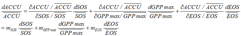
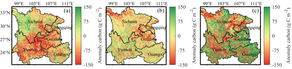
干旱对生态系统的可持续性构成了重大威胁,造成中国西南等地区的年累积碳吸收量(ACCU)降低。为理清背后的潜在机制,本研究基于综合物候和生理学统计模型(Statistical Model of Integrated Phenology and Physiology, SMIPP),将ACCU分解为春季物候(Start of Season, SOS)、秋季物候(End of Season, EOS)和生产力峰值(Peak of Gross Primary Productivity, GPPmax),并分析其对干旱的响应。结果显示,物候 (SOS和EOS)和生理 (GPPmax)的组合能很好的捕获ACCU的变异;2001 – 2020年,干旱通过推迟SOS和提前EOS导致ACCU净损失75.90 Tg C。研究结果强调,干旱对ACCU的负面影响主要通过影响物候来实现。总体而言,本研究量化了干旱通过物候和生理效应对ACCU的贡献,可为未来干旱条件下生态系统碳循环预测提供依据。
已有研究发现,ACCU与春季物候(Start of Season, SOS)、秋季物候(End of Season, EOS)和生产力峰值(Peak of Gross Primary Productivity, GPPmax)密切相关。干旱以不同的方式影响SOS、EOS和GPPmax,例如,春季干旱使植物因缺水而推迟生长,导致SOS延后;秋季干旱促进脱落酸分泌,从而提前EOS;夏季干旱可通过限制光合作用而降低GPPmax,但伴随的温度和有效太阳辐射的增加,亦会增加GPPmax。因此,了解SOS、EOS和GPPmax对季节性干旱的响应模式,并通过这些指标量化干旱降低ACCU的程度,对于理解干旱对生态系统碳循环的影响具有重要意义。
中国西南地区在是全球生态恢复工程最为显著的区域,也是中国最大的碳库。然而,近年来气候变化和人类活动对该地区的影响日益显著,导致干旱频繁发生。因此,研究西南地区干旱对生态系统碳吸收的影响,对于维护生态系统的稳定性及保护生态系统功能的完整性至关重要。本研究旨在借助综合物候和生理学统计模型(Statistical Model of Integrated Phenology and Physiology, SMIPP)模型,量化干旱通过对物候(SOS, EOS)和生理(GPPmax)的影响引起的ACCU变化,以便更好地了解干旱对西南地区碳循环的影响。
Jiangliu Xie, Hongfan Gu, Gaofei Yin (2024). Drought decreased annual cumulative carbon uptake in Southwest China mainly through its influence on phenology rather than physiology. Ecological Indicators,158, 111359.
Zhang, G., Ma, H., Liang, S., Jia, A., He, T., Wang, D. 2022. A machine learning method trained by radiative transfer model inversion for generating seven global land and atmospheric estimates from VIIRS top-of-atmosphere observations. Remote Sensing of Environment, 279. 113132. https://doi.org/10.1016/j.rse.2022.113132.
Zhang, G., Liang, S., Ma, H., He, T., Yin, G., Xu, Jiang., Liu, Xiao., Zhang, Yu. 2023. Simultaneous estimation of five temporally regular land variables at seven spatial resolutions from seven satellite data using a multi-scale and multi-depth convolutional neural network. Remote Sensing of Environment, 301. 113928. https://doi.org/10.1016/j.rse.2023.113928.
Zhang, G., Ma, H., Liang, S. 2021. Estimating 250-m Land Surface and Atmospheric Variables From MERSI Top-of-Atmosphere Reflectance. IEEE Transactions on Geoscience and Remote Sensing, 60: 1-16. https://doi.org/10.1109/TGRS.2021.3089232.
J. Geng, Jing-M. Chen, L. Tu*, G. Yin*, H. Jin, J. Huang, J. Roujean., “Evaluation of Path Length Correction for Forest Canopies over Sloping Terrains: Theoretical Derivations and Computer Simulations,” IEEE Transactions on Geoscience and Remote Sensing, doi: 10.1109/TGRS.2023.3334681.(本研究)
J. Geng, J. Roujean, A. Kuusk, Y. Pang, L. Tu*, Jing-M. Chen*, “A Universal Canopy Gap Fraction Model for Forests with Various Tree Distributions Based on Nilson’s Models Considering Directional Overlaps Among Crowns”. Agricultural and Forest Meteorology, Under Review. 2023. http://dx.doi.org/10.2139/ssrn.4570868.
J. Geng,Jing-M. Chen, L. Tu, et al., “Influence of the exclusion distance among trees on gap fraction and foliage clumping index of forest plantations,” Trees, vol. 30, no. 5, pp. 1683-1693, 2016. doi:10.1007/s00468-016-1400-y.
J. Geng, Jing-M. Chen*, L. Tu, et al., “GOFP: A Geometric-Optical Model for Forest Plantations,” IEEE Trans. Geosci. Remote Sensing, vol. 55, no. 9, pp. 5230-5241, 2017. doi:10.1109/TGRS.2017.2704079.
G. Yin, B. Cao, J. Li, et al., “Path Length Correction for Improving Leaf Area Index Measurements Over Sloping Terrains: A Deep Analysis Through Computer Simulation,” IEEE Transactions on Geoscience & Remote Sensing, vol. 58, no. 7, pp. 4573-4589, 2020. doi:10.1109/TGRS.2019.2963366.
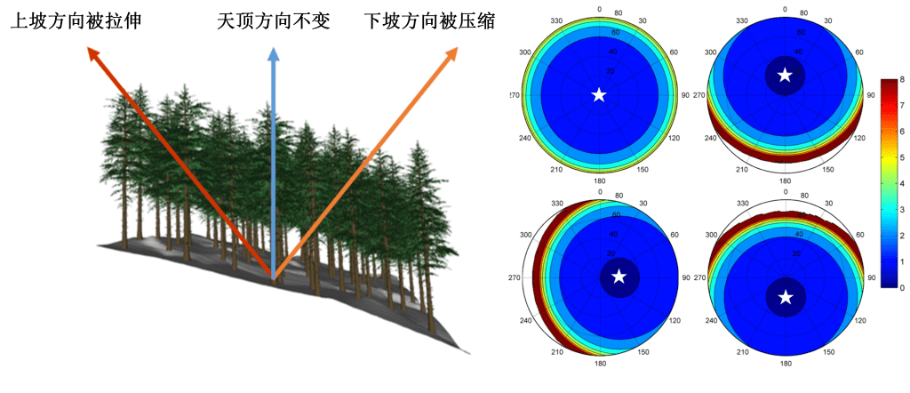
通过理论分析与计算机模拟发现,地形会引起冠层内光子传输路径长度(即消光路径长度)的改变(图2),而消光路径长度的地形依赖性是引起反射率地形效应的关键机制(Yin et al. 2020, IEEE TGRS;Geng et al. 2023, IEEE TGRS)。路径长度的地形依赖性这一关键机制的发现为发展简洁有效的坡地植被冠层反射率模型奠定了坚实的理论基础。
图2地形影响光在冠层内传播路径长度示意图
2. 发展了基于路径长度改正的坡地冠层反射率模型
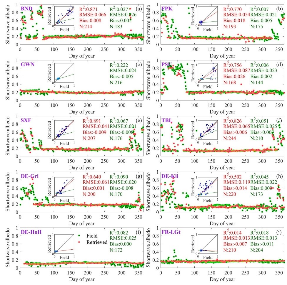
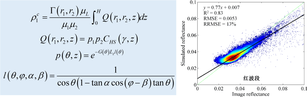
冠层反射率模型描述了辐射与植被冠层交互的物理过程,建立了植被状态与其反射特性之间的物理关系。因此,冠层反射率模型是理解和挖掘光学遥感观测中包含的信息进而估算地表参量的必要工具。从光子在冠层内传输过程的物理机理出发,将冠层反射率表达为路径长度的显函数,并通过将平地路径长度替换为山地消光路径,创造性地提出了基于路径长度改正的山地冠层反射率模型PLC(Path Length Correction)(Yin et al. 2017, IEEE TGRS)。该模型对山地冠层反射率具有较高的模拟精度(图3),为山地植被定量遥感提供了有效理论工具。
图3山地植被反射率模型PLC的解析表达及其对山地冠层反射率的模拟结果
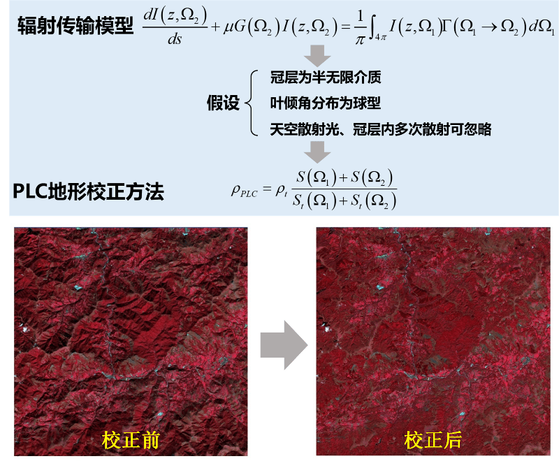
3. 提出了地形校正物理方法
现有地形校正方法大都基于经验或半经验的解析式,未考虑地形对冠层内部辐射传输过程的影响。通过简化山地辐射传输模型,实现其中地形相关量与地形无关量的分离,最终得到了由山地反射率到等效平地反射率的转换关系,首创了基于辐射传输模型简化的植被反射率地形校正方法PLC(Yin et al. 2018, RSE)(图4)。
图4地形校正方法PLC的数学框架及地形校正前后的山地遥感影像
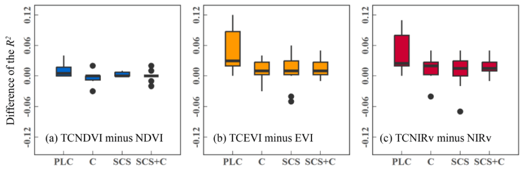
植被近红外反射率植被指数NIRv (Near-infrared Reflectance of Vegetation)是总初级生产力GPP (Gross Primary Production)的有效代理。然而NIRv受到地形显著影响,很难直接应用于高山植被(Chen et al. 2020, RS)。NIRv和PLC都隐含了反射率仅来自于植被的假设,因此通过两者耦合,提出了一种可同时抑制地形和背景影响的新型植被指数TCNIRv(Chen et al. 2022, TGRS),成功地刻画了山地GPP季节动态(图5)。
图5新型植被指数TCNIRv的数学框架及各植被指数与实测GPP的相关性
4. 集成理论方法成果,开展了系列山地生态遥感应用研究
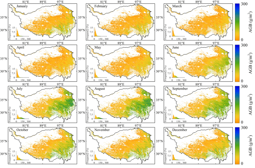
高寒草地参数时空连续反演:提出了一种不依赖于实测数据支持的青藏高原草地生物量物理反演方法,借助GEE云计算平台,实现了大范围、实时、快速反演(图6,Xie et al. 2022, TGRS)。
图6青藏高原草地生物量季相变化
高寒草地光合作用气候限制变迁:通过改进光能利用率模型(EC-LUE),实现了青藏高原总初级生产力(GPP)的长时序估算;结合因子分析方法,刻画了光合作用气候限制的时空动态:青藏高原东部光合作用主要受温度限制而西部主要受水分限制;在年际变化上,水分限制在逐渐增强(图7,Xie et al. 2023, STE)。
图7光合作用水分和温度限制的分布
高寒草地物候遥感监测与驱动机制:提出了一种新型植被指数GRVI,有效解决了高寒草地结构与光合动态在秋季脱耦导致的物候提取难题(Li et al. 2023, AFM)。在此基础上阐明了青藏高原植被物候期与秋季衰落速度的时空动态及其生理生态机制(图8,Tang et al. 2023, EI)。
图8秋季叶片凋落速度LSV与其主控因子空间分布
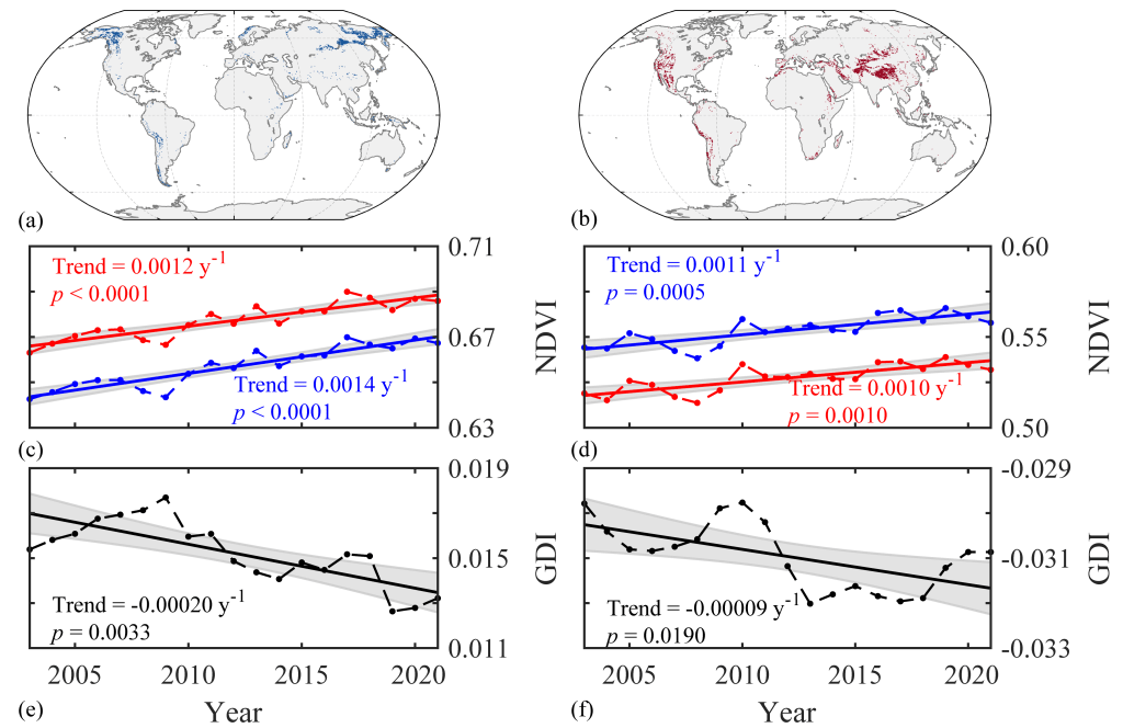
坡向小气候对山地植被影响的遥感探测:在复杂地形区域,不同坡向接收到的辐照度存在显著差异,由此形成的微气候使得在北半球的南坡比北坡更干燥、更温暖。因此,生长在不同坡向上的植被可能呈现出不同生长状态和过程,即坡向效应。课题组率先在全球尺度上研究了坡向效应,发现南北坡植被绿度差异与区域气候条件密切相关,在干热区域北坡植被绿度强于南坡;而在湿冷区域北坡绿度弱于南坡。但不管在何种气候区,北坡变绿趋势强于南坡,导致南北坡植被绿度差异在湿冷区域逐渐减弱,在干热区域则逐渐增强(图9,Yin et al. 2023, GRL)。南北坡植被绿度差异为研究气候如何调节植被生长提供了“自然实验室”,为预测山地生态系统未来趋势提供了新思路。
Yin, G., A. Li, S. Wu, W. Fan, Y. Zeng, K. Yan, B. Xu, J. Li & Q. Liu (2018) PLC: A simple and semi-physical topographic correction method for vegetation canopies based on path length correction. Remote Sensing of Environment, 215, 184-198. (中科院1区,IF=13.5)
Xie, J., G. Yin*, D. Ma, R. Chen, W. Zhao, Q. Xie, C. Wang, S. Lin & W. Yuan (2023) Climatic limitations on grassland photosynthesis over the Tibetan Plateau shifted from temperature to water. Science of The Total Environment, 906. (中科院1区,IF=9.8)
Yin, G., A. Li, W. Zhao, H. Jin, J. Bian & S. Wu (2017) Modeling Canopy Reflectance Over Sloping Terrain Based on Path Length Correction. IEEE Transactions on Geoscience and Remote Sensing, 55, 4597-4609. (中科院1区,IF=8.2)
Yin, G., B. Cao, J. Li, W. Fan, Y. Zeng, B. Xu & W. Zhao (2020) Path Length Correction for Improving Leaf Area Index Measurements Over Sloping Terrains: A Deep Analysis Through Computer Simulation. IEEE Transactions on Geoscience and Remote Sensing, 58, 4573-4589. (中科院1区,IF=8.2)
Yin, G., L. Ma, W. Zhao, Y. Zeng, B. Xu & S. Wu (2020) Topographic Correction for Landsat 8 OLI Vegetation Reflectances Through Path Length Correction: A Comparison Between Explicit and Implicit Methods. IEEE Transactions on Geoscience and Remote Sensing, 58, 8477-8489. (中科院1区,IF=8.2)
Chen, R., G. Yin*, W. Zhao, B. Xu, Y. Zeng, G. Liu & A. Verger (2022) TCNIRv: Topographically Corrected Near-Infrared Reflectance of Vegetation for Tracking Gross Primary Production Over Mountainous Areas. IEEE Transactions on Geoscience and Remote Sensing, 60, 1-10. (中科院1区,IF=8.2)
Xie, J., C. Wang, D. Ma, R. Chen, Q. Xie, B. Xu, W. Zhao & G. Yin* (2022) Generating Spatiotemporally Continuous Grassland Aboveground Biomass on the Tibetan Plateau Through PROSAIL Model Inversion on Google Earth Engine. IEEE Transactions on Geoscience and Remote Sensing, 60, 1-10. (中科院1区,IF=8.2)
Geng, J., J. Chen, L. Tu, G. Yin, H. Jin, J. Huang & J. Roujean (2023). Evaluation of Path Length Correction for Forest Canopies over Sloping Terrains: Theoretical Derivations and Computer Simulations. IEEE Transactions on Geoscience and Remote Sensing. (中科院1区,IF=8.2)
Chen, R., G. Yin*, G. Liu, Y. Yang, C. Wang, Q. Xie, W. Zhao & A. Verger (2023) Correction of illumination effects on seasonal divergent NIRv photosynthetic phenology. Agricultural and Forest Meteorology, 339. (中科院1区,IF=6.2)
Li, W., R. Chen, D. Ma, C. Wang, Y. Yang, C. Wang, H. Chen & G. Yin* (2023) Tracking autumn photosynthetic phenology on Tibetan plateau grassland with the green–red vegetation index. Agricultural and Forest Meteorology, 339. (中科院1区,IF=6.2)
Yin, G., J. Xie, D. Ma, Q. Xie, A. Verger, A. Descals, I. Filella & J. Peñuelas (2023) Aspect Matters: Unravelling Microclimate Impacts on Mountain Greenness and Greening. Geophysical Research Letters. (中科院1区,IF=5.2)
Chen, R., G. Yin*, W. Zhao, K. Yan, S. Wu, D. Hao & G. Liu (2023c) Topographic Correction of Optical Remote Sensing Images in Mountainous Areas: A systematic review. IEEE Geoscience and Remote Sensing Magazine, 2-22. (中科院2区,IF=14.6)
Tang, Y., R. Chen, J. Xie, D. Ma, C. Wang, C. Wang, Q. Xie & G. Yin* (2023) Spatiotemporal variations of leaf senescence velocity on the Tibetan Plateau grasslands. Ecological Indicators, 156. (中科院2区,IF=6.9)
Chen, R., G. Yin*, G. Liu, J. Li & A. Verger (2020) Evaluation and Normalization of Topographic Effects on Vegetation Indices. Remote Sensing, 12. (中科院2区,IF=5.0)
Yin, G., J. Li, B. Xu, Y. Zeng, S. Wu, K. Yan, A. Verger & G. Liu (2020) PLC-C: An Integrated Method for Sentinel-2 Topographic and Angular Normalization. IEEE Geoscience and Remote Sensing Letters, 18, 1446-1450. (中科院2区,IF=4.8)
Chen, Z., R. Chen, Y. Yang, H. Pan, Q. Xie, C. Wang, B. Xu & G. Yin* (2023) Decreased Sensitivity of Grassland Spring Phenology to Temperature on the Tibetan Plateau. IEEE Journal of Selected Topics in Applied Earth Observations and Remote Sensing, 16, 4371-4382. (中科院3区,IF=5.5)
Chen, R., G. Yin*, B. Xu & G. Liu (2023) Topographic Effects on Optical Remote Sensing: Simulations by PLC Model. IEEE Journal of Selected Topics in Applied Earth Observations and Remote Sensing, 16, 9977-9988. (中科院3区,IF=5.5)
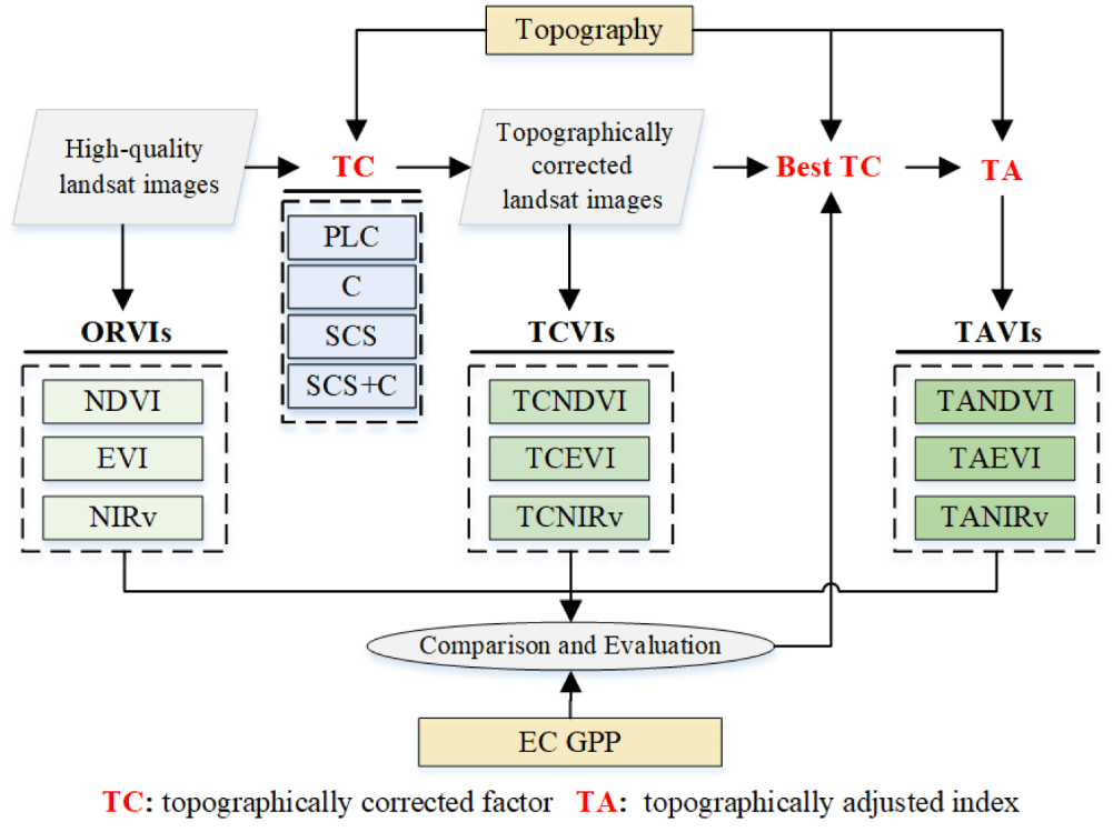
Xinyao Xie, Wei Zhao, Gaofei Yin, 2023. TAVIs: Topographically adjusted vegetation index for a reliable proxy of gross primary productivity in mountain ecosystems. IEEE Transactions on Geoscience and Remote Sensing, doi: 10.1109/TGRS.2023.3336727
Rui Chen, Gaofei Yin, Wei Zhao, Baodong Xu, Yelu Zeng, Guoxiang Liu, Aleixandre Verger. (2022). TCNIRv: Topographically Corrected Near-Infrared Reflectance of Vegetation for Tracking Gross Primary Production Over Mountainous Areas. IEEE Transactions on Geoscience and Remote Sensing, 60, 1–10, doi: 10.1109/TGRS.2022.3149655.